Perhaps the most important of the Landmark features is the provision
of many clear and easily comprehended maps. These are placed
throughout the text, each map located within or adjacent to the
episode which it supports. Every known city, town, shrine, river,
mountain, or other geographic feature that appears in the narrative is
referenced in the text by a footnote to a nearby map or, in some cases
where the site is tangential to the plot, to a reference map at the very
end of the book. Those maps which display many labels employ a
simple coordinate system to help readers search for particular sites. In
the interest of clarity, each map displays the names of only those
features that appear in the surrounding text. If the location of a place
is unknown, the footnote says so. If we moderns are not sure of a site’s
location, our uncertainty is mentioned in the footnote and indicated
on the map with a question mark. A few maps have been designed to
support the book’s introduction or some of the appendices, and they
are also placed near the relevant text.
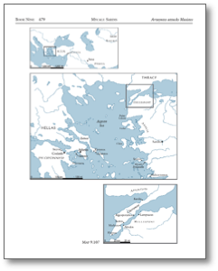
Although a number of maps are single images, many are double or
triple, arranged in a telescoping format from small scale (wide scope)
to large scale (detailed scope). Thus the reader often finds a series of
maps which are to be read from the top down, as their scale increases.
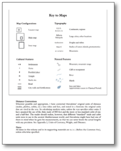
A Key to Maps is located just before the historian’s text begins, and
contains a complete legend of typography and symbols used, and an
illustration of the map border frame system. In the sample map
(Herodotus, Map 9.107, which means it is located in Book 9 by
Chapter 107), the top map stretches some 3,000 miles, from Italy to
Baktria. The next map extends some 400 miles, centered on the
Aegean Sea, and the lowest map covers sixty miles of the Hellespont
and Chersonese region. [Next page]
Copyright © 2010 by Robert B. Strassler
Sample Key to Maps
Landmark Features
In Print
Forthcoming


